Packet Radio
Overview of applications: Specialist Additions
-
DX Cluster
-
APRS (Amateur Position Reporting System)
-
TCP/IP (Networking over AX.25)
-
NTTP (Newsgroups / Usenet group mail)
-
POP3 / SMTP (Email)
-
HTTP (Web pages)
-
FTP (File Transfer)
-
DX Cluster is a system of reporting "DX" you hear ("Spotting") and then everyone reading shortly afterwards the information.
MixW can update a DX Cluster table that can control your Rig (Band, Mode, Frequency) by CAT, if your rig has this feature. The MixW DX Cluster dialog can be updated by Packet or Internet. You can use it to enter new "Spots" to the DX Cluster (DXC) system via internet. Or you can connect to a packet DX Cluster node and enter new spots
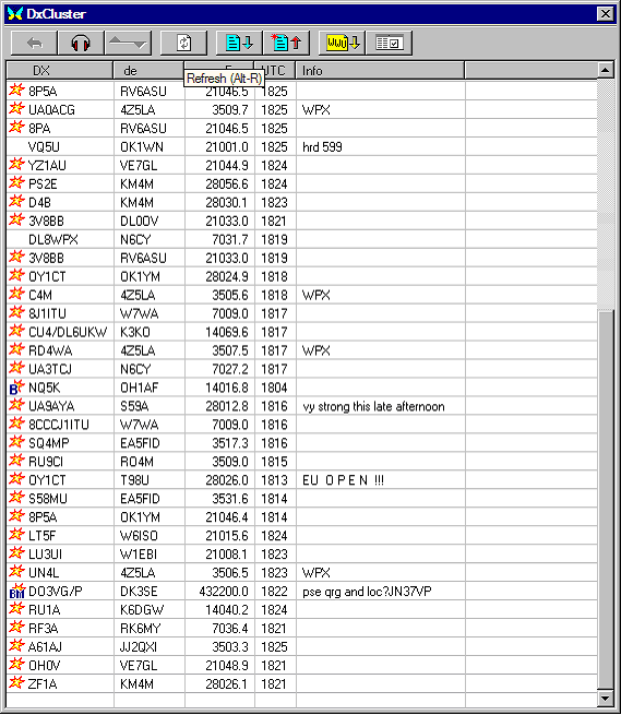
As you can see from the MixW screen shot the information is neatly laid out and in addition you can "filter" in preferences whichs bands and/or modes interest you.
If the DXC dialog is open and you have Broadband it will fill up as above. In fact I have the "Internet" loading option disabled as I don't have broadband and don't want a big phone bill. The above DXC information was loaded automatically by packet. If ANYONE connects to a Packet DXC that results in DXC traffic "heard" by your station, even if you are using APRS, TCP/IP, Keyboard QSO, Conference, BBS, YAPP or whatever the MixW DXC dialog table will still automatically load!
|
Typical connect dialog to a DXC node running DXSpider, one of the better DX Cluster server applications. |
connect ei3pkt-2 |
APRS
APRS stands for Automatic Position Reporting System. Mac/WinAPRS is a program for utilizing mapping and GPS technology along with Ham radio (packet) for use in tracking real time geographically related information such as the location of vehicles or the status of weather. It has many many facets and uses.
* Here is WinAPRS Documentation
APRS need not actually connect a real GPS handset to a mobile rig. A repeater or weather station can use APRS to "beacon" position or send automated weather reports. A user with a handheld, PDA or Laptop and good map skills can manually enter APRS data without a GPS handset.
Some handhelds have a built in packet modem and small pocket sized packet modems can Interface ordinary 2m handhelds a Palm PDA and/or a Garmin GPS handset to automatically report position.
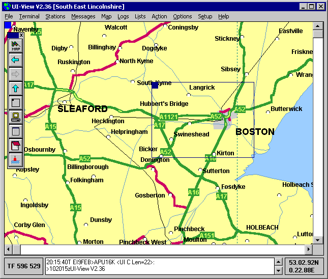
UIview also can use GPS directly or via APRS. It does not mention MixW as a Packet system, but it can use a KISS TNC. MixW can create a pair of "Virtual Com Ports", say COM5 and COM6 that are "looped". You then "emulate KISS TNC" on MixW on COM5 and connect UIView to the COM6 to access the APRS data broadcast on packet. Maps can be downloaded or scanned into UIview.
"Radio Mobile" coverage mapping / prediction software can also have a selected "Unit" posiotn updated by GPS or APRS. In the case of a locally connected GPS, the position information can be sent either in Terminal Virtual COM Port mode or via TCP/IP to MixW, AWGPE or FlexNet packet systems.
